Create and use evacuation zones across jurisdictions within an open, interoperable framework.
Create, Share, and Coordinate Zones Across Jurisdictions
OEZ provides a shared framework for managing evacuation zones across jurisdictions. Agencies can create or integrate zones at no cost and publish them in an open format that any system can use. Zones remain fully editable, allowing emergency managers to update boundaries and zone statuses as incidents evolve.
Zone Management
Create and Modify Zones
Generate new evacuation zones or integrate existing ones without changing current workflows. Zones remain editable at all times, including during active incidents.
Interoperability
Share Zones Across Systems
OEZ publishes zone data in an open format that integrates with mapping tools, emergency management platforms, and regional coordination systems.
Public Communication
Connect Zones to Alerts and Public Apps
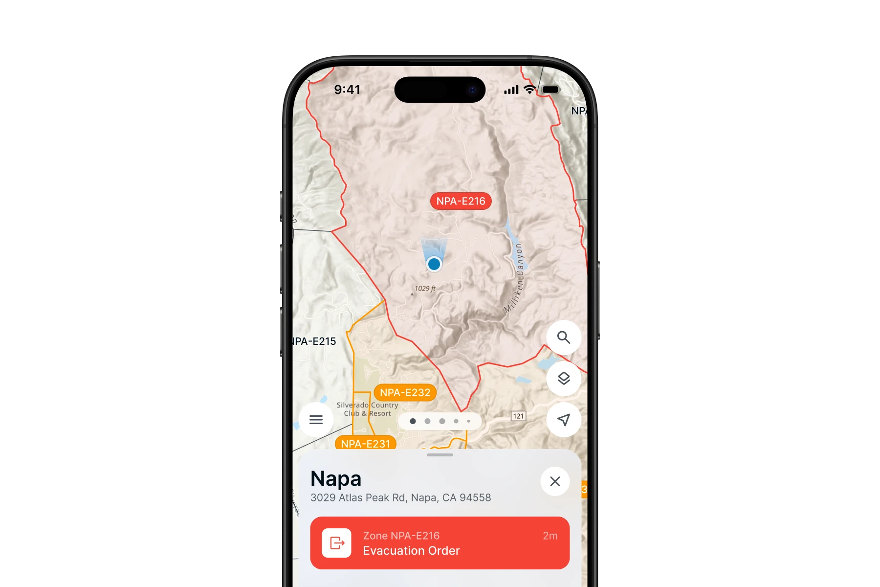
Zones integrate with alert and warning systems and public-facing tools like Sentinel, allowing agencies to immediately share evacuation status and updates with residents.
Operational Benefits
Coordination Without Complexity
Free and Open for Government Agencies
OEZ is available at no cost to counties, cities, and state agencies through the Ladris Core Open Tier. Local governments can create zones, integrate existing data, and share information without licensing barriers.
Wildfires, floods, and other disasters often cross county lines. OEZ enables agencies to maintain a consistent view of evacuation zones across jurisdictions, improving coordination between emergency managers, law enforcement, and fire agencies.
Connect Zones to Public Information
OEZ zones can be paired with public-facing tools that help residents understand evacuation status and available resources. Agencies can attach banners, safety resources, and notifications that reflect local priorities and incident conditions.
OEZ supports agencies responsible for coordinating evacuation operations across jurisdictions. It helps maintain situational awareness, organize protective actions, and communicate consistent information during incidents.
Coordinate Across County Lines
OEZ gives every agency a shared zone framework so evacuation information stays consistent when disasters cross jurisdictional boundaries.
Integrate with Any System
Zone data publishes in an open format compatible with any mapping tool, alert platform, or emergency management system. No workflow changes required.
Maintain a Unified Regional View
Emergency managers, law enforcement, and fire agencies share a continuously updated picture of evacuation zones to support faster, collaborative decisions.
Get Started with Ladris for Free
Try Ladris at no cost and experience how one integrated platform helps agencies prepare, model, and act with confidence.
.webp)


.webp)