Sentinel Prime

Field Intelligence for Every Responder

Real-time fire projections, zone status, and evacuation recommendations in the hands of every person on the ground.
Tablet and smartphone displaying a wildfire mapping app showing Milliken Creek Fire in Napa, CA with fire area, containment percent, evacuation zones, affected assets, and control point details.

Tactical Awareness Without the Command Post

Sentinel Prime runs on the Ladris Core intelligence engine, processing live incident data to deliver field-level situational awareness and tactical recommendations on iOS and Android devices. Firefighters, law enforcement, and emergency personnel get the same intelligence previously limited to command posts — available the moment they need it.
Live Incident Data

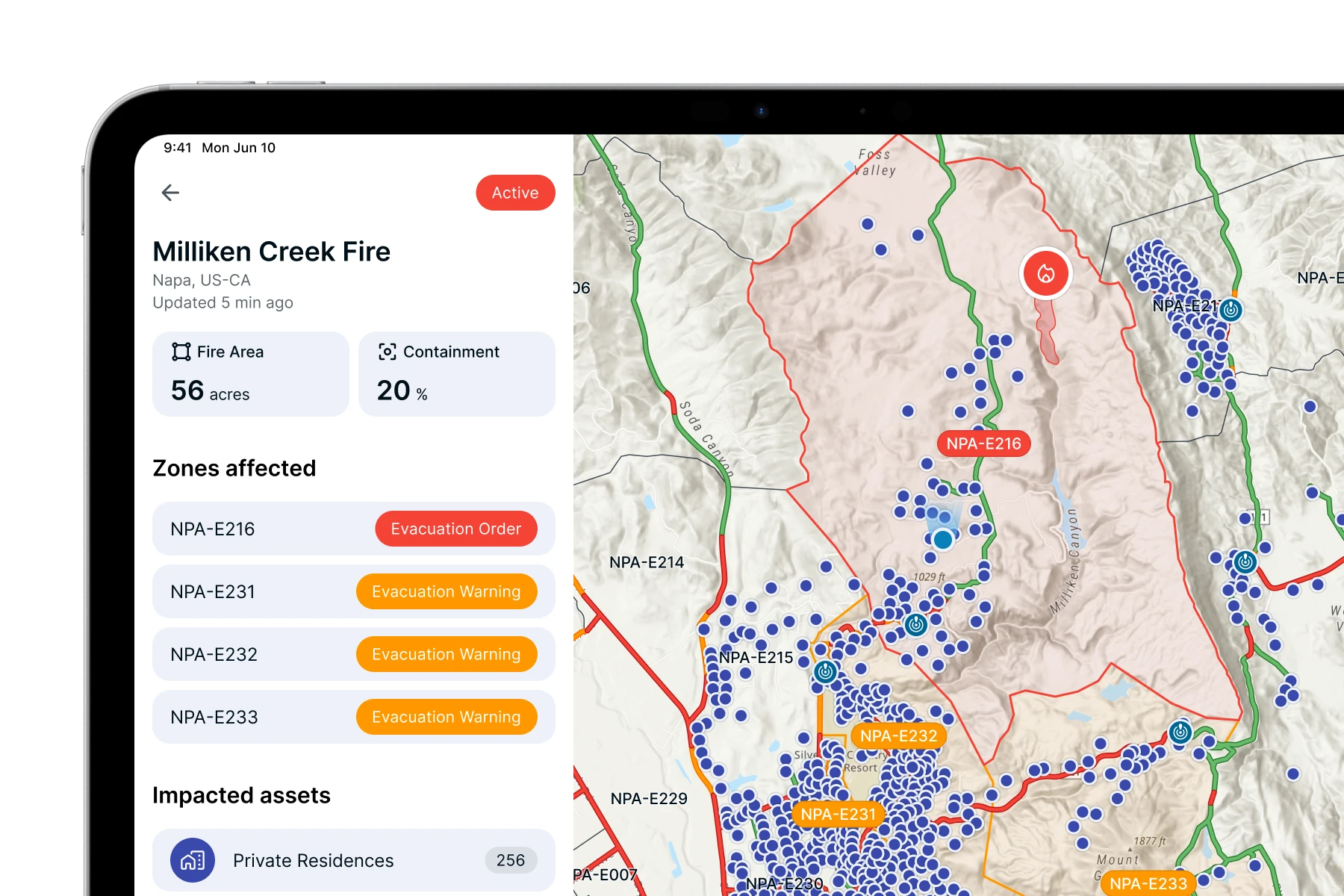
Real-Time Fire and Zone Intelligence

Displays current fire perimeters, zone status, and evacuation warnings, all updated continuously as conditions change.
Fire Behavior Modeling

Fire Spread Projections from Any Point

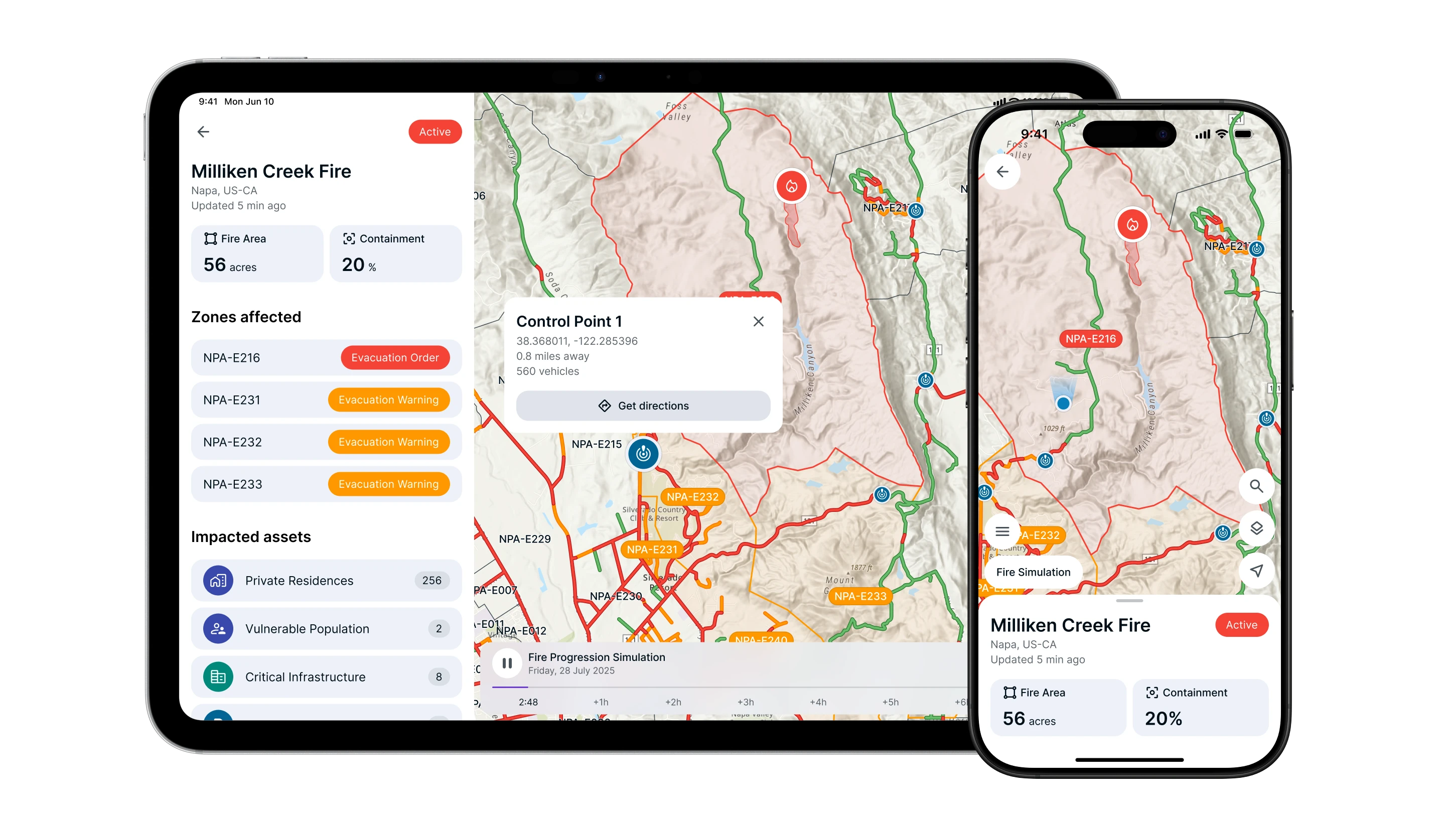
Projects fire spread from origin points and active perimeters, giving responders an immediate picture of where fire is heading.
Field Operations

Built for Active Operations

Tracks active incidents alongside live evacuation simulations, maintaining a shared operational picture as conditions and priorities evolve.
Key Advantages

The Full Operational Picture, in Your Pocket

Map showing Milliken Creek Fire near Napa, California with fire area of 56 acres and 20% containment, evacuation orders for zone NPA-E216, and evacuation warnings for zones NPA-E231, NPA-E232, and NPA-E233.

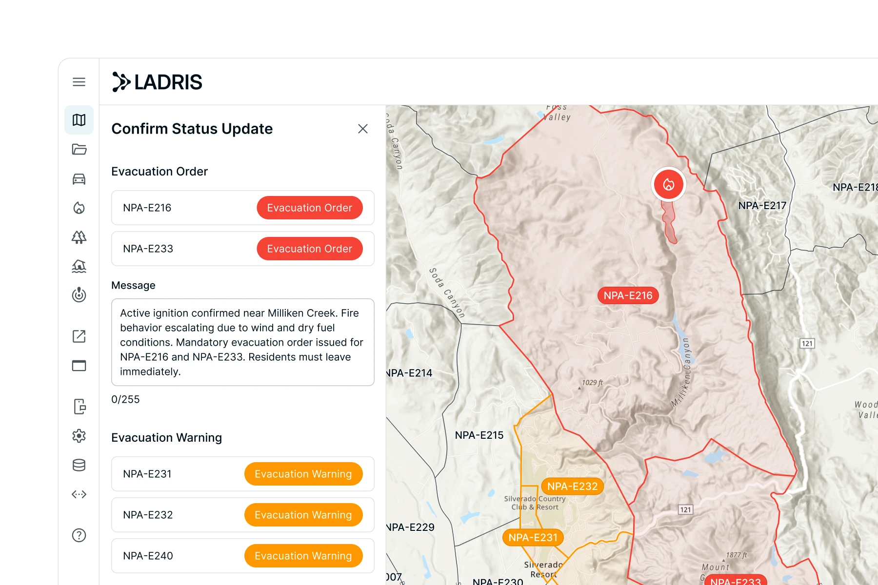
Evacuation Intelligence at the Point of Decision

Sentinel Prime delivers explicit evacuation recommendations based on live fire behavior modeling — so field teams can act on the same data driving command-level decisions, without waiting for a briefing.

Multi-Incident Tracking Across Your Jurisdiction

The Active Incident Index gives responders a real-time view of all active incidents across their jurisdiction, enabling coordination for teams operating across multiple fronts.
Mobile app screen showing a list of current wildfire incidents with a map of the western United States marking fire locations near California and Nevada.
LADRIS interface showing a wildfire evacuation status update with a map; red areas indicate evacuation orders for zones NPA-E216 and NPA-E233, and orange areas show evacuation warnings for zones NPA-E231, NPA-E232, and NPA-E240.

Integrated with the Systems You Already Use

Sentinel Prime integrates with CAD systems and incident management platforms, pulling live fire origin data, CAD alerts, and simulation updates directly into the operations feed without additional setup.
Pikes Peak Regional Emergency Management logo featuring a shield with icons of a snowflake, house on water, lightning, and fire inside a green circular border.
What Customers Say
"Ladris was a dependable and trusted partner in our effort to build a data-driven evacuation plan.”
Andrew Notbohm
Director, Pikes Peak Regional Office of Emergency Management
Seal of Yuba County, California, featuring mountains, a logging truck, peaches, and a cow divided into four quadrants.
What Customers Say
"You can’t put a price on life. Ladris is essential and that’s why we budget for it."
Oscar Marin
Emergency Manager, County of Yuba
Seal of Jefferson County, Washington with green pine trees, snow-capped mountains, and a fish inside a white circular border on a light blue background.
What Customers Say
“The Ladris modeling software gave us an unprecedented ability to help state officials find the safest dates for a critical infrastructure project.”
Wilie Bence
Director, Jefferson County Department of Emergency Management

Built for the People on the Ground

Sentinel Prime is designed for emergency personnel who need immediate access to incident intelligence during active operations.
Firefighters and Suppression Teams
Access live fire perimeters, spread projections, and suppression priorities as conditions develop.
Law Enforcement
View traffic control point mapping, zone status, and evacuation priorities to support coordinated public movement.
Forward Deployed Operations Personnel
Access fire projections, zone status, and evacuation priorities to stay aligned with field and command teams.

Get Started with Ladris for Free

Try Ladris at no cost and experience how one integrated platform helps agencies prepare, model, and act with confidence.